Ohio URISA, which is a statewide GIS organization, is having a New GIS Technologies Day at ODOT in Columbus on July 17th. It looks like an all day, running from 9 to 4pm.
More Information is Here.
You need to join URISA to attend- for free. It's only $10 for a student membership- think for the price of a couple of cigarettes, you can network with a bunch of GIS professionals and stay up to date on what's fresh in GIS.
Thursday, June 11, 2009
Tuesday, June 2, 2009
Career Thoughts
There a constant conversation about jobs here and for good reason. Everyone would like the one job, 40 hours a week, full salary and benefits position, and they still exist, depending on the economy.
However, thinking about the state of the auto business or newspaper business, the one killer job that you hold for 30 years is disappearing faster than a couch on a porch in Athens.
Here's another approach to consider. What is intriguing is the idea of getting many employers to pay you a little and bundling that into a living. It's certainly a high wire act at times (and the author is a successful journo with years in the business), but when you're young may be the easiest time to do it (lower overhead, less need for insurance, ability to take some risk). Instead of waiting for the layoff or worrying about the next paycheck, you go out and make it happen.
Sunday, May 31, 2009
Kinder, Gentler through Type
This morning's paper has an article on how corporations are undergoing a wave of logo redesigns in order to soften them in these tough times.
Instead of the Masters of the Universe, ALL CAPS, logos, lower case is becoming the rule. Indicators of "greenness" are popular. And even Blackwater, the para-military corporation has changed it's logo, of course it was brought on by a name change in that case (to Xe, which seems vaguely chinese to me- are they aiming for new markets?).
Instead of the Masters of the Universe, ALL CAPS, logos, lower case is becoming the rule. Indicators of "greenness" are popular. And even Blackwater, the para-military corporation has changed it's logo, of course it was brought on by a name change in that case (to Xe, which seems vaguely chinese to me- are they aiming for new markets?).
Tuesday, May 19, 2009
GPS Fail Blog
The Guardian Newspaper is reporting that GPS satellites, some more than 20 years old, could start failing in 2010. They obtained a GAO report saying that "delays and overspending are putting the entire system in jeopardy".
As Very Spatial blog pointed out there are a bunch of sats up there, so it's probably not quite as dire as it seems. But if you add this report to the threat of increased solar flares, which also have the potential to disrupt the system, next year could be an interesting GPS year. Now, in what corner did I crumple my paper atlas!
As Very Spatial blog pointed out there are a bunch of sats up there, so it's probably not quite as dire as it seems. But if you add this report to the threat of increased solar flares, which also have the potential to disrupt the system, next year could be an interesting GPS year. Now, in what corner did I crumple my paper atlas!
Sunday, May 17, 2009
You never think you're going to use it
Tomorrow at 8am we'll have another session of webGIS. I'm not sure anyone ever thinks that they're going to use what they learn in class, but here's another example of online GIS.
The NYT has this google map app showing the location of all of the Chrysler dealers that are going away as a result of the bankruptcy. Not sure if the rest become Ciat or Fodge or Fisler, when the Fiat deal goes through.
The NYT has this google map app showing the location of all of the Chrysler dealers that are going away as a result of the bankruptcy. Not sure if the rest become Ciat or Fodge or Fisler, when the Fiat deal goes through.
Tuesday, May 5, 2009
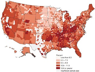
Mental Health Mapping
via National Geographic News, a map that details the percentage of residents by county who have experienced "frequent mental distress".
The article notes that Kentucky is the bluest and Hawaii is the happiest. No surprise to anyone who follows UK basketball.
The article notes that Kentucky is the bluest and Hawaii is the happiest. No surprise to anyone who follows UK basketball.
One Nation under Seven Deadly Sins
During a long winter and rainy spring, while waiting for the latest grant cycle to select winners and losers, geographers undertake some interesting research.
At Kansas State, they've analyzed and mapped the seven deadly sins across the United States. Discretion being the better part of valor, I'll let you make your own conclusions regarding the results.
At Kansas State, they've analyzed and mapped the seven deadly sins across the United States. Discretion being the better part of valor, I'll let you make your own conclusions regarding the results.
Davey GIS Position
I noticed on the bulletin board that Davey has a GIS position in Lexington,KY. I'll post more information as I get it.
Update: I think this is the position description.
Update: I think this is the position description.
Wednesday, April 29, 2009
SVG break through
Once in a while, you beak around the web and find great things...
Here is an SVG based interactive web mapping site put together by the USDA to show agricultural statistics.
It combines so many things that our students are taught. From using SVG and javascript to make interactive web products to using color schemes from the color brewer web site (where else would those yellow-green classifications schemes come from?!)(on second thought, did Dr. Brewer invent yellow?).
This shows 2002 data but who cares. In fact the 2007 data is all in pdfs or gifs- in other words, no interactivity, no use creativity, just static presentation.
Hocking River Kayak Race
I'm reminded that there is a kayak race on the Hocking River that has been put together by geology prof Dr. Mike Caudill, here at Hocking. All fingers are crossed for a little bit more rain on Thursday and Friday to get the Hocking up to at least 6 feet. If you're interested, go to the Canaan Township Highway garage (off 50), east of Athens.

H1N1 Map Mania
Today we rush to fill the hysteria void by noting that students in the internet mapping class will be delighted to see the New York Times H1N1* interactive map coverage
Although created in Adobe Flash, it is very similar to some of the SVG/Javascript stuff you've done. Of particular note, the interactive map uses a point/buffer approach to locating cases of the H1N1* flu. This is instead of condemning large swaths of territory to the flu designation based on one or two cases (as noted by John Stewart on The Daily Show).
*I call it the H1N1 flu in keeping with newly announced White House policy. It seems that when everyone and his brother calls it the S* Flu, pork sales are impacted both domestically and internationally. The Obama Administration is taking the lead in calling the virus by its scientific name in hopes of ending the perception that pork and this flu are connected. Coincidentally, while there is most certainly a hog, bird & human connection because of the genetics of the virus, public health in Mexico has yet to find a hog with this particular strain.
Wednesday, April 15, 2009
Some Week
Some weeks, it just doesn't pay to get out of bed.
In case you haven't heard, Hocking College has, once again, downgraded the GIS/GPS program ending the associates degree and looking at developing a one year certificate. I got the news early this week.
Today was the more difficult day, because I didn't really relish telling my students who have put their full faith and credit in the program that because of forces outside their control, the program was being cut. The college has promised to continue the classes for another year and I hope that is true.
And to top it off, I got home to a basement with an inch and a half of water due to a blown hot water heater; and by blown, I mean a hole in the side due to a spike in water pressure, I suspect (the second time I've seen this in two months in two different water systems in my life). The word to the wise is make sure you have an in house pressure regulator if you rely on a rural water system.
I'm reminded of a joke my dad tells on occasion about Job. After all of the afflictions and crap that visit his life, he asks "why god?" and the reply comes back "there's just something that I don't like about you".
Tuesday, April 14, 2009
Kayaking, GIS & GPS combined
University of Tennessee bio-systems engineers have combined kayaking, GPS equipment and lasers to map stream conditions. The data will then be brought into a GIS to create planning maps.
It's definitely a cool combination of technology and kayaking. Is it the only way to do this- doubtful, but bio-systems engineers don't get paid to use pencils and paper!

It's definitely a cool combination of technology and kayaking. Is it the only way to do this- doubtful, but bio-systems engineers don't get paid to use pencils and paper!
Sunday, March 8, 2009
State of Ohio & USA Jobs
Tomorrow in Employment Seminar we'll be discussing both the State of Ohio jobs website and USA Jobs .
Both sites allow you to create accounts that you can post typical application information, resumes, etc. so that when the perfect job appears, all you have to do is tweak things for the position and apply. The USA Jobs site also has a feature where you can publicly post your resume for recruiters to scan when they have positions to fill.
As I was strolling through the USA Jobs site, using GIS as a keyword, I came across several temp "cartography" positions with the National Park Service in Colorado. How cool would that be?! I also saw that the Ohio ODNR GIMS division is looking for interns- and it includes traveling around field verifying. Another fun way to spend the Summer.
As some of you know (and you'll be sorry, I'm letting a few more people know- although readership of the blog might be around one at this point!) these sites are incredibly easy to navigate and a routine of once a week might set you up for a new position in government. Good Luck.
Monday, March 2, 2009
Las Vegas Over 25 years
NASAs Image(s) of the Day show Las Vegas over the past 25 years- a facinating look at unbridled growth in the desert. Ironically, Las Vegas is spanish for The Meadows.
The 25 year time period matches the lifetime of the Landsat5 satellite, originally built to last 5 years (begs the question: Is life on the surface of the earth so debilitating that we can't get 5 times the planned life out of something like a car?).
Guess what happens when gambling slows down due to the economy and the water dries up? Stay tuned for the next 5 years of Las Vegas images.
GIS Drainage Intern Fayette Soil & Water
Jackie passes along this annual announcement:
Fayette Soil and Water Conservation District (Washington Court House) is looking for a GIS intern, familiar with ESRI GIS software. Duties include editing, checking, attributing and creating spatial databases related to hydrography, topography, transportation and cadastre (parcels). Experience with survey or GPS is a plus.
They pay $8 per hour for 480 hours.
Application deadline is April 1, 2009.
See me if you want the complete job announcement.
If Fayette SWCD isn't near where you'll be this Summer, you may want to check with your local SWCD to see if they're hiring interns.
Sunday, February 15, 2009
Career Couch Strikes again with another great article
Another Career Couch article worth reading: A Cover Letter is not Expendable .
Three things stand out for me in this article:
1. 25% of applicants to one job mentioned neglected to include a cover letter; most were within 5 years of graduating from college.
2. Something as old fashioned as mailing your cover letter and resume, in addition to emailing everything gets attention (probably because most people don't bother).
3. Hiring managers look for ways to exclude you during the hiring process (ironic that the hiring process isn't about hiring at all)
It is entirely possible that I like this article because it supports everything that I've been teaching in class. And that I constantly worry that the informal atmosphere in school reinforces the informality that I see in students (incomplete or late assignments, texting during labs, etc.), which is the kiss of death when you are looking for a career-track position (or a recommendation for that matter).
I'll make a weak analogy to just getting your license and convincing your parents that you are responsible enough to take the family wheels on your own. The attitudes that your parents have were formed at least 20 years ago. Your parents are worried that you'll do something irresponsible, like speed or run red lights, that will lead to damaging the car at the least or yourself and others at the worst. So, your whole goal in convincing them that you're an acceptable risk is to tap into their attitudes and do all the things that they expect and none of the things that would freak them out. So you wear your seatbelt, drive 5mph below the speed limit, you head check, signal and come to a full stop.
Similarly in the hiring process, the people doing the hiring have attitudes and expectations of what applicants will do that were formed a while ago and in trial by fire. They're worried that the person they hire will perform poorly, resulting in more work for them, long periods of anguish and a damaged reputation. Your whole goal, like convincing your parents, is to tap into what their expectations are and meet or exceed them; hence the cover letter & resume, etc., etc.
Everyone knows that learning to write a cover letter is like learning to use a clutch- it seems impossible when the car stalls the first few times and you've got a line of cars behind you, but after time, it gets easier.
When you think of it, after reading the article, how funny is it that something as old fashioned as mailing your cover letter and resume as a follow up to an electronic submission is now seen as something that can get you extra attention and an interview.
Monday, February 9, 2009
O, Canada
Two cool things about this article in the Leader-Post Saskatchewan, Canada.
One, geographic information systems (GIS) analysts are listed as one of several career fields that are experiencing growth due to demand in "green" sector employment (construction, auditing, etc.).
Two, geographic information systems (GIS) analysts are listed along side engineering, environmental techs and conservation biologists like its something people have some knowledge of. There's no paragraph description of what GIS is, etc. A sign that GIS is becoming mainstream? At least in Saskatchewan.
Downside about this article. The jobs that they're discussing aren't in southeast Ohio. But they could be...
Thursday, February 5, 2009
GPS Apps II class for Tuesday, February 10th
A couple of students will have the time to create a schedule for occupying control points and the corner stones, so the rest of you can come in at the regular time.
I also had a chance to download the TDS data from Tuesday and the internal results were good. I need Doug to decipher the distances for me to get a report on how the TDS results match reality.
John mentioned inversing between the points to get the distance (which the GPS software and most software that works with coordinates does automatically). The formula to accomplish this (from Wolf & Ghilani) is
LengthAB = √(change in X)2 + (change in Y)2
in english, to get the length between points A and B, you take the square root of the (X coordinate of A minus the X coordinate of B) squared plus (the Y coordinate of A minus the Y coordinate of B) squared.
Its a good thing to know how to do in the field as a check for the results that you are getting. Besides you have a lot of time on your hands during a static survey- you gotta have something to do besides read...
Thursday, January 29, 2009
Don't throw it into the fire!
I don't know about you, but as I crumple up paper to start a fire, I usually end up scanning the headlines as I go. This one caught my eye just before it went into the furnace- You May Not Like It, But Learn to Network
It's from the Career Couch column by Phillis Korkki and it runs every Sunday in the New York Times. This one is a Q&A on networking and it's a gem. Discussing questions like:
It may disappoint some of you, but she ends by cautioning people against spending too much time online networking. "It is still the face-to-face networking that tends to seal the deal."
It's from the Career Couch column by Phillis Korkki and it runs every Sunday in the New York Times. This one is a Q&A on networking and it's a gem. Discussing questions like:
- Aren't you just using people when you network?
- Is it too late to start networking?
- How do you expand your network?
- What about the role of technology?
It may disappoint some of you, but she ends by cautioning people against spending too much time online networking. "It is still the face-to-face networking that tends to seal the deal."
Storm of the Century
Looks like the Storm of the Century ™ (someone has to call it the storm of the century) has knocked Hocking off it's stride yesterday and today. Just as well, as I didn't want students to feel like they needed to risk icy roads this evening to attend class.
A great opportunity for all of you to read a great book or catch up on work and sleep, because you know every instructor in the joint will be cramming the two missed days (a week's worth of classes in many cases) into the remaining quarter. BTW: a shout out to intermediate GIS folks- the class exercise is posted if you want to try it at home! We could probably do the class via blog & class webpage- haha!
Out here in the sticks, two nights ago were spent listening to ice laden trees and branches give up and come down. The power finally gave up about mid-morning, but the AEP crews dug deep and got it re-connected by late evening. The trees are still coated in ice, so if the wind picks up before the ice melts, things are going to get interesting again...
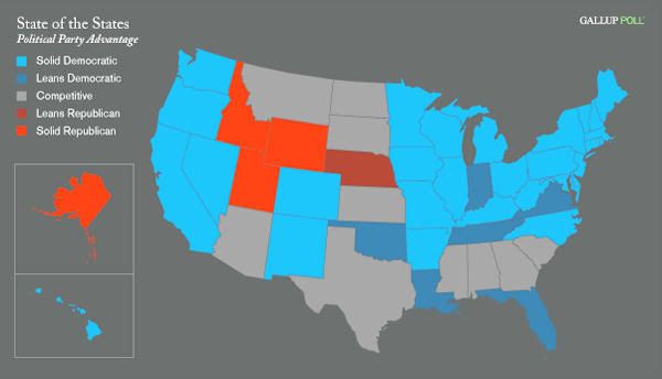
What's wrong with this map?
Politics aside, the choices in this map from Gallop get in the way of easily imparting the information. Any guesses why quantitative/qualitative sportsfans?
Thursday, January 22, 2009
GIS Tech Position WV State Historic Preservation
This one probably slipped through the radar because it was posted in the classified section of a West Virginia newspaper.
The West Virginia Department of Culture and History (aka state historic preservation office) is looking for GIS Techs to do digitizing on a contract basis. GIS and GPS experience is helpful but not required. I think that their focus is college students or anyone that wants to work on an 800 hour contract for $13.00 an hour (you can work 40 hours straight or fit it into your existing schedule and work fewer hours per week). The job is based in Charleston, West Virginia, a hop, skip and less than two hours away from Athens, Ohio.
I spoke with Tami Koontz who is the IS and GIS System Administrator. She is happy to take resumes or your questions via email
Sunday, January 18, 2009
file management problem solved?
One of the big problems that I notice that students have is having access to data files, map files or any files at home or at school without remembering where the flash drive is or remembering to copy from the workstation hard drive to the flash and so on.
Well, in the paper of record business section this morning comes a review of two online services: Syncplicity and Dropbox.
be forewarned, until you hear otherwise, that you maybe exposing your home computer if you use a NR215 workstation and these services
These are services that syncronize files across computers. Syncplicity will even sync google doc files. So, if you're in the middle of a paper and decide to leave for home, when you arrive home the paper will be available exactly where you left off. They're encrypted, but I'm not sure from the review how well it'd all work if one of your computers is a publically accessible lab workstation. Best part is that the service is free for up to 2Gb (great for GIS files as long as you don't include imagery!!!).
More on this as we test it in labs.
Thursday, January 15, 2009
If we were only paying more attention
I was reviewing my notes from my Intro GIS class from the Spring of 2007 and I ran across this map and article.
The map shows subprime mortgages as a percentage of all mortgages in a county(?). The accompanying article talks about a rise in defaults and foreclosures in- get this- March of 2007. By the Spring of 2008, "connected" money managers had pulled out of the stock market, leaving the rest of us to take the bath (one friend had a retirement advisor boast about how they avoided the mess by getting out of the markets by early 2008, not realizing the next question would be "why the hell didn't you give me a call"). Who knows where it's going to go a year from now...
The map shows subprime mortgages as a percentage of all mortgages in a county(?). The accompanying article talks about a rise in defaults and foreclosures in- get this- March of 2007. By the Spring of 2008, "connected" money managers had pulled out of the stock market, leaving the rest of us to take the bath (one friend had a retirement advisor boast about how they avoided the mess by getting out of the markets by early 2008, not realizing the next question would be "why the hell didn't you give me a call"). Who knows where it's going to go a year from now...
Tuesday, January 13, 2009
National GIS Proposal
Proposal for a National GIS from Jack Dangermond, ESRI Dear Leader and Anne Hale Miglarese (Booz Allen Hamilton- a major worldwide consulting firm & obtainer of federal monies).
Suspending reality, this could be a really great thing- a national parcel database, solid elevation data, current national imagery. The possibilities would be endless. And the job creation would be big to create it and continue with analysis and maintenance jobs. Why should all the job creation be in construction?
Bringing in reality, though, this could be a huge boondoggle. Every effort to update or modernize federal computer systems goes way over budget and results in silos (see IRS & FBI attempts). TIGER data via the census was questionable for years, and they actually have folks on the ground to field check data. And considering where the proposal is coming from, would the result be like privatizing the military through contracts or would it have a federal agency home? Finally, how would this be maintained once the economy improves and we have to start paying our way again.
update: there is now a website devoted to this idea GIS Nation. I've seen comments ranging from fantastic idea to an ESRI bailout plan.
Highlights of the Proposal from GISuser.com blog...
The Stimulus Plan being developed by Congress and the incoming Obama Administration is an enormous undertaking to revive the American economy. Potentially, it will involve thousands of infrastructure and other projects intended to create jobs and restart economic growth while producing things of lasting value to American taxpayers. The challenge to properly manage and execute this effort will be daunting, requiring unprecedented access to data and information at all levels of government and the private sector.
This is the moment for America to build a national Geographic Information System (GIS), that is, a unified, up-to-date, publicly-accessible national digital map, enriched with data from all available sources, and supported by GIS technology. This system can be built quickly, immediately creating high tech jobs, and will serve as a public resource for project planners to support transportation infrastructure, water resource management, alternative energy research, and project siting. It will also provide a foundation for monitoring the US economic recovery across our communities, allowing activities to get underway as soon as possible and leaving a legacy for the future.
A National GIS, properly designed and effectively implemented, providing public access and using best technologies, will speed economic recovery by producing jobs and putting shovels in the ground more quickly.
Monday, January 12, 2009
GIS Jobs & Careers website
Justin sends in the following link:
GIS Jobs & GIS Careers Western US GIS job links and general GIS job related sites.
It looks like a site with a million possible places to look for a job and failing that a million places that might be hiring at some point. At the very bottom is some search advice (once again, a lot of it comes down to your network- your contacts).
A tail of Cell Phones, GPS & Google mapping
From Worcester, MA Telegram (an F'ing A shoutout), comes this story.
Apparently, Grannie was stealing a granddaughter from one family to deliver to another. Cops were able to track the kid by getting the cell phone company to report the lat. & long. every time her phone was used (not sure if they were getting lat/longs from a GPS equiped cell phone that captures the phone's locations and attaches it to the electronic info that is transmitted along with your voice or whether the lat/long was determined using the three nearest cell towers when the phone pinged the towers- either method exists).
Then, using Google mapping products including street view & sat imagery, the police were able to map the lat/longs and determine what motel Grannie and granddaughter were staying at.
No Numb3rs. No CSI. Just plain old digital mapping tools.
And remember next time you embark on a life of crime, bring plenty of quarters and stick to payphones.
Thursday, January 8, 2009
Ohio Adjunct General 3 GIS Positions
Mark emails word of a position at the Ohio Adjunct General's office. Thanks Mark.
Link at Government Jobs the Ohio government job website.
Job Title: GIMS Intern
PN: 20076480, 6481, 6482
Agency: Adjutant General
Opening Date: Wed. 07/23/08
State Salary Range: $0.00 / Hour
Job Type: Seasonal, Temporary, Exempt
Location: Franklin County, Ohio
Promotional Bid: N/A
Pay Range Based on academic level
Hours of Work 7:30 a.m. - 4:30 p.m.
Division Facility Support/Master Planning
Job Location Adjutant General's Department 2825 W. Dublin Granville Road Columbus, OH 43235
Description
Under direction of Geographic Information Management System (GIMS) Administrator, assists with GIS & CADD data generation & analysis; operates GIS & CADD software (ArcGIS, ArcInfo & AutoCAD Map) to produce &/or revise maps & engineering design drawings; conducts site surveys, collects & prepares spatial data for digitization into GIS & CADD; scans engineering drawings & project plans; enters data into geospatial databases.
Operates a government vehicle to travel to sites around Ohio to conduct surveys, site visits & data collection; assists supervisor with special projects &/or reports as needed; performs related office duties (e.g., maintains project files, attends meeting, performs data entry, etc.).
---3 POSITIONS AVAILABLE---
Minimum Qualifications:
Must show proof of current enrollment in a college/university and be in good academic standing. Preferred Majors: GIS, Environmental Science, Geography, Engineering, Surveying, Geodetic Science, or related field with coursework in GIS, environmental studies & policy. Experience with Internet based programs, Microsoft Office, GPS, CADD, and GIS products.
Major Worker Characteristics:
May be exposed to inclement weather, rough terrain, insects & poisonous plants.
Must have valid driver's license
Supplemental Information:
The rate of pay is based on the student's academic level:
Undergraduate Student: $7.00 - $14.72
Graduate Student: $7.00 - $17.91
Friday, January 2, 2009
Wildlife Ringtones
Way cool selection of ringtones from the Center for Biological Diversity. They're called RareEarth Tones . The selection is way broader than the enature.com site. The grizzly and polar bears are sweet.
Subscribe to:
Posts (Atom)
